Moti Daman Fort
Moti Daman Fort is a large sea‑side fort built by the Portuguese in the late 1500s to control the port of Daman and protect their trade along the Arabian Sea coast. It is still used today as an administrative area, so when you walk inside, you are literally moving through a “living” piece of history where old churches, offices, houses and walls are all mixed together.
Where the story begins
Before the Portuguese came, the site of Moti Daman was already important because a Muslim stronghold, ruled by an Abyssinian (Habshi) chief, controlled the port and the trade here. The Portuguese, who were expert sailors, wanted safe harbours on the west coast of India to secure the spice and sea trade routes between Goa and their homeland in Europe.Between 1529 and 1559 they attacked this port several times, trying to remove the earlier rulers and take full control of the creek where the Damanganga river meets the sea. Finally, in 1559, the Governor of Goa, Constantino de Bragança, arrived with warships and thousands of soldiers, captured Daman, and placed a Portuguese captain with troops to guard the area.
Building the fort (1559–1593)
Once the Portuguese had captured Daman, they decided that the old local fort was not enough for their long‑term plans. So, they demolished the earlier fortification and started building a new and much larger fort on the south bank of the river, which is what we now call Moti Daman Fort. Construction began in 1559 and went on for more than twenty years, finishing in stages. An inscription on the south gate records that work there was completed in 1581, while another on the north gate shows that the full fort was ready by 1593, meaning it took about 24 years to finish the entire complex.
The Portuguese also built a smaller fort on the opposite (north) side of the river, called Nani Daman Fort, but Moti Daman was the main settlement and military base, which is why it is larger and more elaborate.
The fort’s layout and architecture
Moti Daman Fort covers roughly 30,000 square metres (around 84 acres), enclosing a sizeable part of the old town. Its basic shape is simple and roughly rectangular, but the walls are thick and strengthened with ten arrow‑shaped bastions (projections) that allowed soldiers to place cannons and watch over the sea, river, and land approaches.On the southern side there was a defensive moat (a ditch that once held water) and on the northern side the natural protection came from the river itself. The fort has two main gates: the Land Gate on the southern side, facing inland, and the Sea Gate on the northern side, opening towards the river and sea routes.
If you walk from the Land Gate to the Sea Gate, you follow the main internal street, which once held barracks and other military buildings for Portuguese defence personnel. Even today, the walls still have old cannons, some with decorative carvings, reminding visitors that this was primarily a military structure meant to keep enemies—especially the Mughals and rival powers—away from the coast.
A “small Portuguese town” inside
What makes Moti Daman Fort special is that it was not only a fort but also the heart of Portuguese life in Daman. Inside the walls they built churches, monasteries, official residences, schools and houses, turning it into a complete European‑style township adapted to Indian conditions.
Important buildings inside include:
- Administrator’s Secretariat and Government House – official residences and offices where administration is still carried on today.
- Cathedral of Bom Jesus and other churches (Our Lady of the Rosary, Our Lady of Remedies) – major religious centres showing typical Portuguese church architecture.
- Dominican Monastery (often called Saint Dominican Monastery) – once a grand religious and learning complex, later damaged during fighting in 1961.
- Bocage House – associated with the Portuguese poet Bocage, remembered locally as the “poet’s house”.
- An old lighthouse – giving wide views over Moti Daman, Nani Daman and the beach, helping ships navigate safely to the harbour..
Because many of these buildings are still used—by government offices, schools, courts, and the municipal council—the fort feels less like a museum and more like an old quarter of a town that has never stopped functioning.
The fort in recent times
After 1961, Moti Daman remained an administrative centre for the Union Territory, and many colonial‑era buildings were converted into Indian government offices, quarters, schools, health centres, and the district library. Visitors walking through the fort today will find quiet streets, old stone houses, gardens, and public buildings all within the same walls that once guarded Portuguese soldiers. Although some parts have suffered from natural wear and tear and are in a state of disrepair, much of the basic structure—walls, bastions, gates and several major buildings—still stands, giving a good idea of how a 16th‑century Portuguese coastal fort looked and functioned. The moss‑covered stone walls, surviving cannons, and mix of European and Indian building styles together make it an important heritage site for the region.
Why Moti Daman Fort matters
For a common visitor, Moti Daman Fort tells several overlapping stories at once. It shows how European powers like the Portuguese used forts and ports to control sea trade and influence Indian coastal politics in the 1500s and later.
At the same time, it preserves the memory of everyday life—church services, school lessons, official meetings, and family homes—inside a fortified town that has continued to be lived in right up to the present. Finally, its role in the 1961 liberation reminds us how these old colonial spaces became part of modern India, turning from foreign strongholds into local administrative and cultural centres.
St. Jerome’s Fort
St. Jerome’s Fort in Daman tells a gripping tale of Portuguese grit against mighty foes in India’s coastal history. Built as a shield for trade routes, it stands today as a quiet reminder of colonial defense in simple stone.
Portuguese sailors first grabbed Daman from local Gujarati rulers around 1559, turning it into a bustling trade hub for spices and silks along the Arabian Sea. But trouble brewed when they seized a Mughal merchant ship in 1611, sparking a fierce Mughal raid that looted nearby lands—though the main fort held firm. This wake-up call pushed them to fortify the smaller Nani Daman side across the Damanganga River.
Work kicked off in 1615 under Viceroy Dom Jerónimo de Azevedo, with engineer Júlio Simão leading the charge—Jesuit priests even pitched in despite their church duties. Named for Saint Jerome, the revered Catholic scholar, the fort wrapped up most construction by 1627, with tweaks lasting into the late 1600s to house 400 soldiers. Picture it like a giant, tall wall hugging 12,250 square meters, not a bulky castle but a smart riverfront shield with a moat to slow enemy advances.
Design for Defense
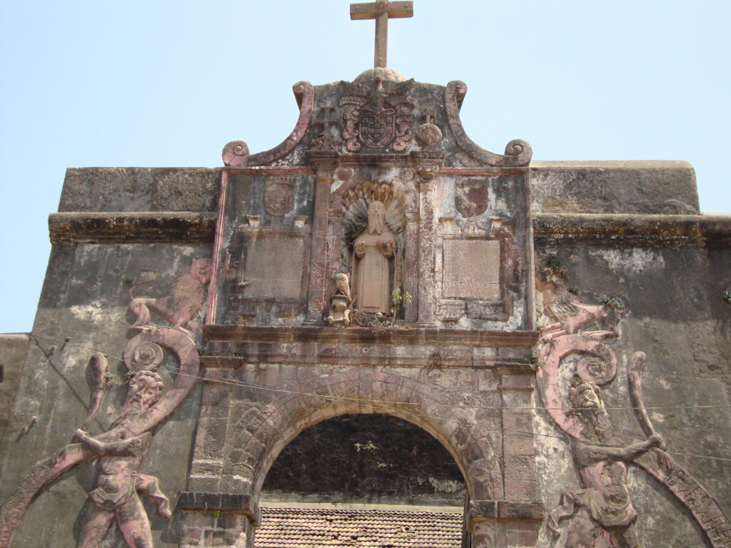
Thick stone walls rose high with three pointy bastions—São Jerónimo, Santo Inácio, and São Francisco Xavier—angled landward to blast Mughal armies or rival Dutch and English ships. The south gate boasts giant carved figures clutching millstones, warning intruders with a cheeky inscription about paying a heavy price to enter, topped by St. Jerome’s statue under Portugal’s coat of arms. Inside, spike-studded wooden doors repelled war elephants, while barracks, ammo stores, and the Church of Our Lady of the Sea kept troops fed and faithful.
Battles and Quiet Years
The fort backed bigger clashes, like the 1638-39 Mughal siege on Daman and a 1692-93 war flare-up, helping Portuguese cling to power for centuries. By 1808, it sheltered 631 locals amid growing calm. In a dark footnote, it hosted the empire’s final public hanging just before Portugal ditched capital punishment in 1870.
Indian Dawn
India’s army rolled into Daman in December 1961, ending 400 years of Portuguese rule without a fight at this outpost. Today, it guards river views, a school in the old church, a cemetery, and government spots—free to wander from dawn till dusk for sunset snaps.